
#027 - Charts from CHS
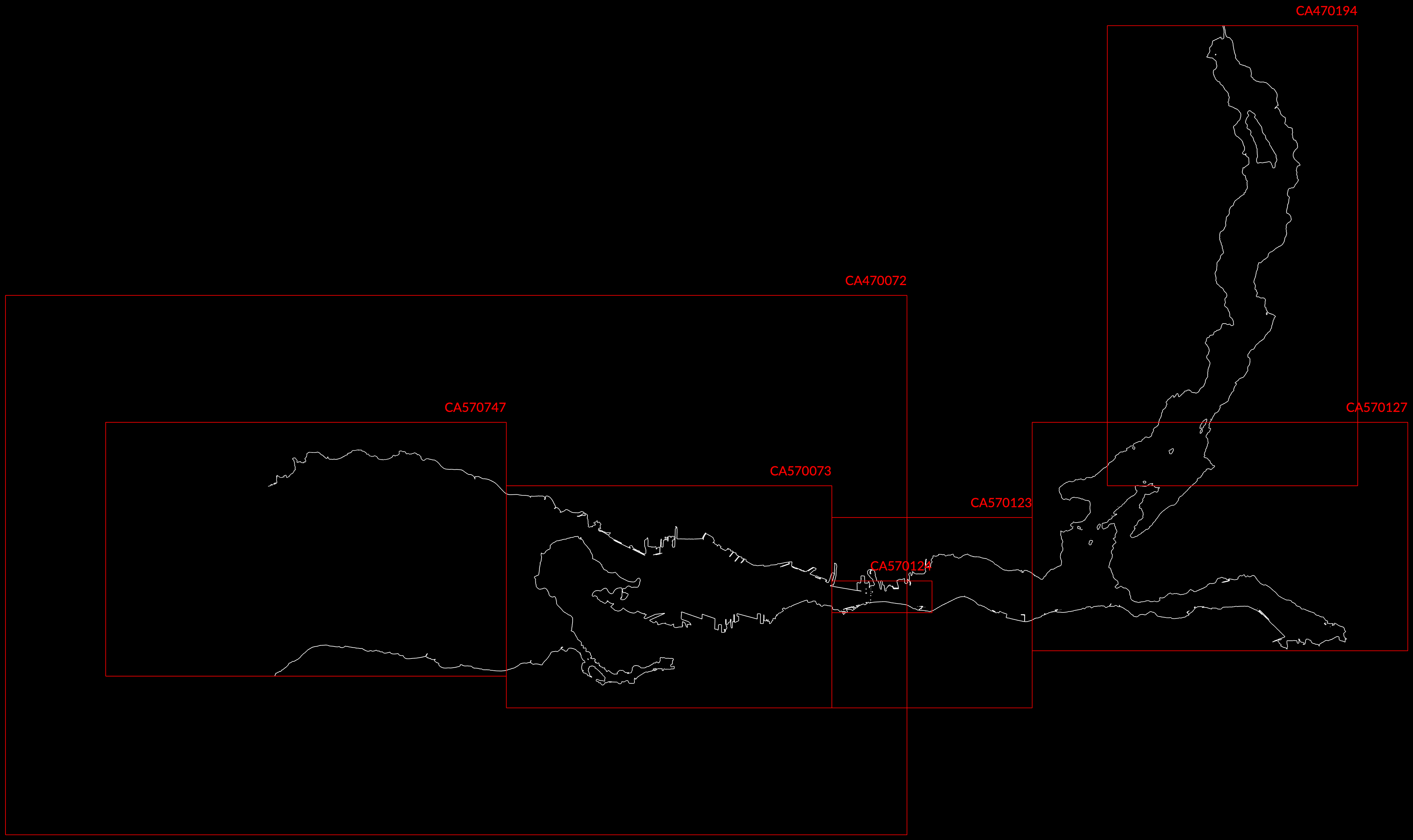
For reference, these are the digital S-57 ENC (Electronic Navigational Chart) regions for Burrard Inlet from CHS (Canadian Hydrographic Service) at DFO (Department of Fisheries and Oceans).
Name={'CA470194';'CA570073';'CA570123';'CA570127';'CA570747'; ...
    'CA570124';'CA470072';'CA370145'};
minLon=[-122.93;-123.17;-123.04;-122.96;-123.33;-123.04;-123.37;-123.97];
minLat=[49.33;49.26;49.26;49.278;49.27;49.29;49.22;48.83];
maxLon=[-122.83;-123.04;-122.96;-122.81;-123.17;-123.00;-123.01;-122.75];
maxLat=[49.475;49.33;49.32;49.35;49.35;49.30;49.39;49.37];

figure('Position',[120,60,1420,780],'Resize','off','Color','k');hold on;
plot(ENC2020(:,1),ENC2020(:,2),'w');axis off;axis tight;

for i=1:length(minLon)-1
x=[minLon(i),maxLon(i),maxLon(i),minLon(i),minLon(i)];
y=[minLat(i),minLat(i),maxLat(i),maxLat(i),minLat(i)];
plot(x,y,'r');
string={Name{i},' ',' '};
text(maxLon(i),maxLat(i),string,'HorizontalAlignment','right','Color','r');
end
CA470194 [GOT IT] - Indian Arm
Title	Indian Arm - Continuation A
Scale	1:15000
Min Longitude	-122.93
Min Latitude	49.33
Max Longitude	-122.83
Max Latitude	49.47
Edition Label 1	5
Edition Label 2	2012-12-13T00:00:00
Edition Label 3	2012
Id	CA470194
Country	CA
Projection	Mercator

CA570073 [GOT IT] - Inner Harbour
Title	Vancouver Harbour, Western Portion\Partie Ouest
Scale	1:5000
Min Longitude	-123.17
Min Latitude	49.26
Max Longitude	-123.04
Max Latitude	49.33
Edition Label 1	7
Edition Label 2	2013-11-01T00:00:00
Edition Label 3	2013
Id	CA570073
Country	CA
Projection	Mercator

CA570123 [GOT IT] - Central Harbour
Title	Vancouver Harbour, Central Portion\Partie Centrale
Scale	1:5000
Min Longitude	-123.04
Min Latitude	49.26
Max Longitude	-122.96
Max Latitude	49.32
Edition Label 1	5
Edition Label 2	2012-12-19T00:00:00
Edition Label 3	2012
Id	CA570123
Country	CA
Projection	Mercator

CA570127 [GOT IT] - Port Moody
Title	Vancouver Harbour, Eastern Portion\Partie Est
Scale	1:5000
Min Longitude	-122.96
Min Latitude	49.28
Max Longitude	-122.81
Max Latitude	49.35
Edition Label 1	7
Edition Label 2	2012-12-10T00:00:00
Edition Label 3	2012
Id	CA570127
Country	CA
Projection	Mercator

CA570747 [GOT IT] - Outer Harbour
Title	Approaches to/Approches \xE0 Vancouver Harbour
Scale	1:6000
Min Longitude	-123.33
Min Latitude	49.27
Max Longitude	-123.17
Max Latitude	49.35
Edition Label 1
Edition Label 2
Edition Label 3
Id	CA570747
Country	CA
Projection	Mercator

CA570124
Title	Second Narrows
Scale	1:3000
Min Longitude	-123.04
Min Latitude	49.29
Max Longitude	-123.00
Max Latitude	49.30
Edition Label 1	6
Edition Label 2	2010-12-09T00:00:00
Edition Label 3	2010
Id	CA570124
Country	CA
Projection	Mercator

CA470072
Title	Approaches to\Approches a Vancouver Harbour
Scale	1:12500
Min Longitude	-123.37
Min Latitude	49.22
Max Longitude	-123.01
Max Latitude	49.39
Edition Label 1	8
Edition Label 2	2012-04-11T00:00:00
Edition Label 3	2012
Id	CA470072
Country	CA
Projection	Mercator

CA370145
Title	Strait of Georgia, Southern Portion\Partie Sud
Scale	1:40000
Min Longitude	-123.97
Min Latitude	48.83
Max Longitude	-122.75
Max Latitude	49.37
Edition Label 1	8
Edition Label 2	2011-11-10T00:00:00
Edition Label 3	2011
Id	CA370145
Country	CA
Projection	Mercator