
#008 - When Stanley Park was an island
Modern altimetry can be used to reveal human-made landscape engineering even after decades of layered change. Shown below is Stanley Park, downtown Vancouver, and False Creek colored in logarithmic scale, with colder blue-green colors for underwater regions and warmer yellow-red for dry land. The shoreline and sea level share coloration in the dark purple range, at 0m elevation (where log transformation yields negative infinity, so its manually colored). The uniform altimetry of the regions closer to sea level hint that the connections to land by the former islands have been landfilled, and were likely drowned by high tides in the past. This is observed on page 11 of Bruce Macdonald’s ‘Vancouver: A Visual History’, the grassy isthmus of what is now Second Beach (quadrant M4 in the illustrated map) explains why Stanley Park was often shown as an island on early maps.
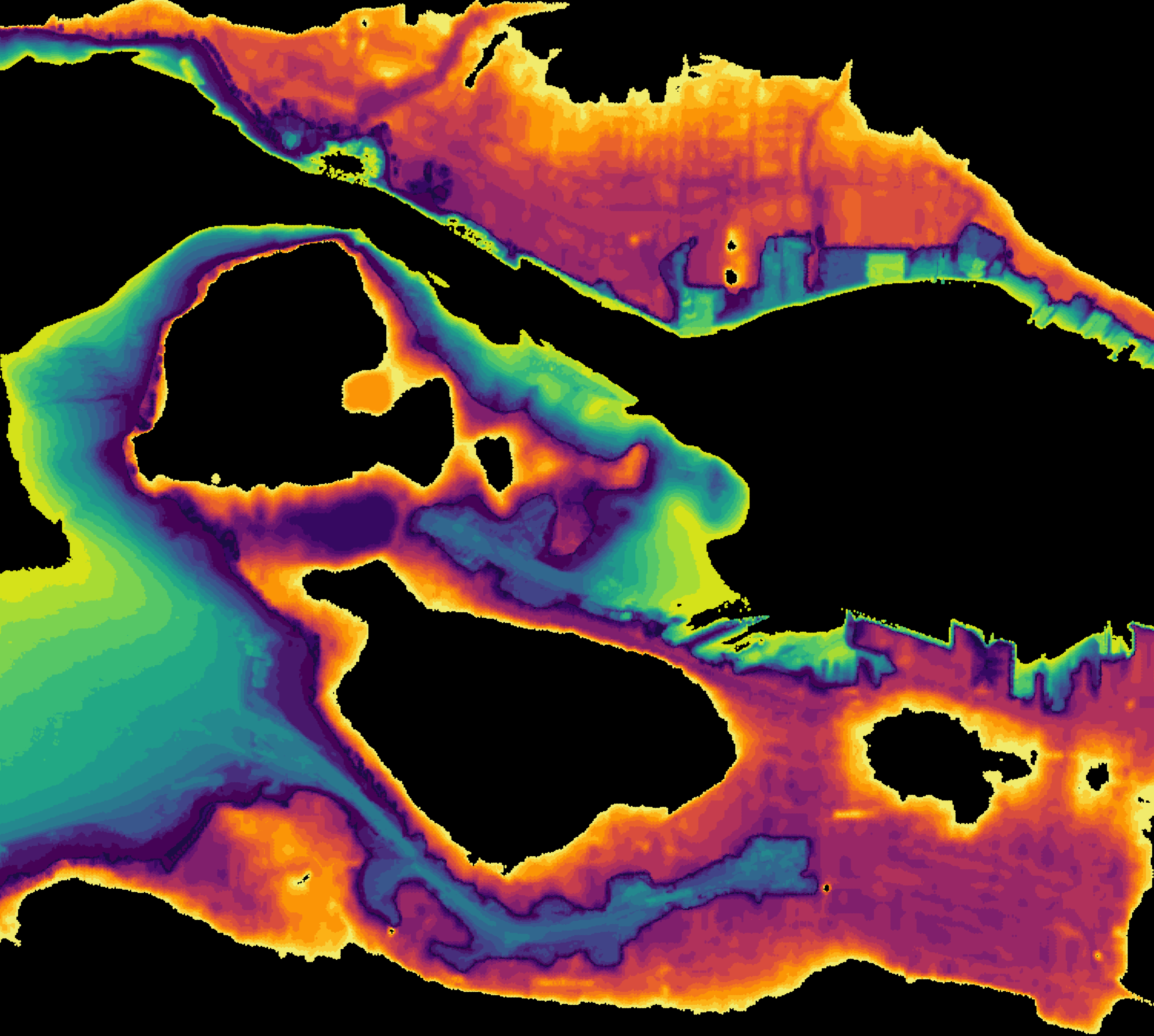
Vancouver resident Donald Burton, born just after the turn of the century, remembers completely circumnavigating Stanley Park in a canoe without once having to portage. This was done by paddling from Deadman Island towards Lost Lagoon under a wooden bridge that stood where the solid causeway is now, then across Lost Lagoon into a creek on its western end that, at high tide, became a navigable stream that drained into the light surf of Burrard Inlet at Second Beach. From there it was a matter of continuing around Stanley Park until returning to Coal Harbour and Deadman Island. The Park Superintendent of 1914 noted that the immediate surroundings of the creek were “swampy and practically useless for public use”. To improve this section of the park, 4120 cubic meters of fill were added, alongside a wooden boom to protect city infrastructure at Second Beach from winter storm surge. According to a 1916 report, the land between Second Beach and Lost Lagoon was so shallow that waves completely covered the area at high tide, explaining the lack of trees. Second Beach as we know it in 2020 is the product of decades of landfill engineering. The creek still survives today, but its cut off from draining at Second Beach. Furthermore, because Lost Lagoon is also cut from the tides of Coal Harbour and filled by rain inflow instead of brackish water, the creek is now a narrow freshwater pond that meanders westward, an annex of Lost Lagoon. Because it is now fed by freshwater creeks from Stanley Park, altimetric data shows that Lost Lagoon is now permanently about 3 meters above sea level.
Many thanks to archeologist Jesse Morin who found the information shared above, based on page 104 of ‘The Stanley Park Explorer’, a 1985 book by Richard Steele.